
Clouds can form some imaginative formations, but a new one on me is a cloud street.
A cloud street, or more technically a horizontal convective roll, is actually a long row of cumulus clouds that is aligned parallel to the direction of the wind. They usually form straight rows, but when the wind hits an obstacle, the clouds might curl into patterns, which are known as von Kármán vortex streets.
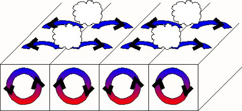
Image via NOAA.
Their formation starts with rising warm air and sinking cool air. First, rising warm air cools gradually as it gains altitude. The clouds form when moisture in the warm air mass cools and condenses. At the same time, sinking cool air on either side of the cloud formation zone creates a cloud-free area. Sometime later, a cloud street develops when several of these alternating rising and sinking air masses line up with the wind.
There are some nice satellite photos at “Cloud Streets: What Are They? How Do They Form?” (https://earthsky.org/earth/what-are-cloud-streets/?), which was the source for this piece.